Monday, September 5, 2011

Working Our Way Home Through Washington

9/2/11 Day 28- On the road from Idaho to Washington. As you can tell from the scenery we are close to Lewiston and the great Palouse. Wheat fields, cattle and grain elevators dominated the scenery. A call to Ross confirmed he was home and welcomed us to his place on the way through. After a stop in Moscow for a new sleeping bag (return Ross's) and mattress for Mark (yes, his went flat again for the second night) we brought the Harley into Pullman, WA. It's with mixed emotion that we are back in our home state. We feel so fortunate to be able to have made this journey and experience more of our home country.


Lunch at Vahalla where Ross works. He's scheduled for a long weekend of work for the first home football game at WSU. He hosted us and his Uncle Chris and cousin Chloe at his place for the night! What fun to meet up with family on our trek back over the last mountain range. Mark and I visited with some friends in town while Ross was working. Hey, we finally made it to under the 4,000 ft. elevation!


9/3/11 Day 29 On to Wenatchee on back roads through Steptoe, St. John and Sprague before hooking on to highway 17 at Moses Lake then 28 from Quincy into Wenatchee. The combines were hard at work in the wheat fields and it had a certain beauty seeing the fields in different hues of gold depending on where they were in the harvest. Those machines are amazing how they navigate the sloping acreage. We spent the night in Wenatchee at Dad and Linda's "other" home catching up on some sleep and gearing up for the final jaunt. It was a much appreciated stay to break up the trip across the state.


9/4/11 Day 30 After a whole month on the road we were close to home! From Wenatchee we drove through Plain to Steven's Pass. This was a new road for both of us! We even ran into some neighbors at the little Plain Market! What a small world it is we have found out. Here we are approaching Index and Gold Bar on highway 2. Washington state ranks right up there in awesome and diverse scenery. We feel so lucky to live here after all our travels. After an early dinner stop in Snohomish we tried to keep with our goal of staying off the interstates and traveled the last hour on highway 9 to home.


"Until We Meet Again"


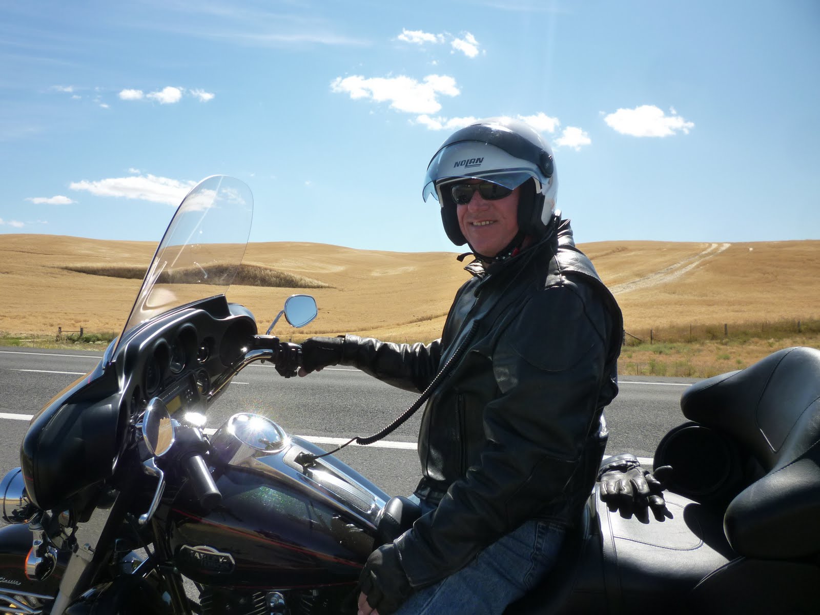
This shot was taken in Colorado by my cousin but we wanted to post it now to show us riding...... Homeward bound and thankful! We know how fortunate we are to be able to make this type of trip happen and we are so grateful to have been able to spend time with my cousins and the rest of our family we saw. God is good and we are blessed. Pulling into our driveway on a sunny evening we felt happy, rejuvinated, and were talking about the next adventure!


End of the 2011 Mountain High Journey. Home again......


Some of the statistics we kept:


* Bike- 2011 Electra Glide Ultra Classic


* Traveled a total of 5, 093.2 miles--- have a total of 15,832 miles on the bike since we bought it a year ago.


* Trip lasted 30 days


16 nights were camping


6 nights in hotels


7 nights in families homes


* Visited 6 states and 3 of them going both ways!


Washington, Idaho, Montana, Wyoming, Utah, & Colorado


* 90% of the routes were on state highways or smaller


* Temperatures ranged from 32-102 degrees- hotter sitting on the bike with gear!


* Premium gas cost ranged from $3.69-4.29 a gallon


* Averaged 40 mpg pulling our little trailer!


* Spent 80% of our trip at elevations higher than 4,500 feet and reached a high of 11,000+ a few times.


* No injuries, no illness, no accidents, no issues (that couldn't be overcome)!


Idaho Beauty Continues

8/31/11 Day 26 continued... Lake Cascade State Park in Cascade, ID. The park has seven different campgrounds with a total of 210 different sites. We picked Sage Bluff because it was right on the lake and there was only one other camper! The lake is huge at about 30 miles long nestled in the mountains of the Boise National Forest. The park was created because of the reservoir's recreational potential and the Cascade Dam was built in 1948 to store water for irrigation. We are still at 4,825 feet elevation! Just can't seem to get under that 4,000 mark! Mr. Larson is taking a break from the wind and sun while I head to the sandy beach to kick back and watch the Osprey dive for fish.


This wonderful campsite had bright red poppies scalloping the edge of our tent spot. We knew we would get some heavy winds so the tent got anchored well! It must be 5:00 somewhere......


Gorgeous view of the sunset from our tent! We saw a few fishermen out for the Coho, bass and perch that the lake boasts before night fell.


9/1/11 Day 27- Well, we knew that the description of the park talked about the "prevailing wind" and boy did it blow! With that and the temp dropping into the 30's it was a chilly night but well worth it for the place. Ski hats and gloves with hot oatmeal and coffee make a perfect morning! No cell or internet reception made it even more relaxing....


Back on the road up highway 55 to McCall. Mark is on the shores of Payette Lake. The North Fork of the Payette River is one side of the road and the lake on the other. We decided we'd like to revisit this town on another trip. Since it was only about 40 miles north of where we'd been it was too early to set up camp!


North on highway 96 inbetween the Payette National Forest to Riggins. This is one of the main entrance towns to all the recreational activities of Hell's Canyon . We saw kayak and rafter's in the Salmon River as we would ride by. Mark has scouted out the Seven Devil's Saloon for a homemade BBQ lunch. The place is named after the mountain range across the road. Great food and a bonus to be able to charge up our phones and camera battery in the spare outlets we could find! We debated between 2 different state parks for the night and the waitress helped us pick. Good choice we soon found out.


Following the Salmon River through Nez Perce National Forest/Hell's Canyon on one side and the Payette National Forest on the other. It was like Vincent van Gogh was in Idaho and Utah -wild sunflowers painted the shoulders yellow along the highways making it so picturesque. Northwest on highway 95- next stop north of Craigmont, ID. Some of the tallest railroad trestles are in this area. We also went through the Camas Plain and White Bird Battlefield, the site of the first confrontation of the Nez Perce War. Rolling rivers, canyons, fields of straw, cattles grazing and wind made us think we were getting close to the Palouse! Temperatures during the day have been in the 60-75 degree range which has been a big change from the previous weeks of over 90 degrees.


Winchester Lake State Park. The campgrounds just keep getting better! This is probably our last night of camping and we marveled at this gem. Our campsite faced the lake that is on the Nez Perce Indian Reservation. Early settlers named the former logging town for the famous firearm. The campground occupies the site of the 1910 Craig Mt. Lumber Co., along the 130 acre lake. The lake has rainbow trout, bullhead and smallmouth bass. It's quiet since no gas motors are allowed on the lake. A nice couple from central Oregon camped next to us.


After a one mile wooded discovery trail hike through ponderosa pine and Douglas fir we walked along the lake and across a foot bridge. It gave us more chances to see squirrels, osprey and Stellar's jays and watch the fishermen along the shores.


Mr. Larson getting another view of the lake from the foot bridge. We were told about the coyotes and Canadian geese that inhabit the area and boy did we hear them in the middle of the night! It was almost like substituting coyote howls for thunder in the canyon! Eating stew around the campfire was a nice ending to a great day. We had another cold night of 35 degrees on our last night in Idaho. Fall has arrived......

Beautiful Idaho - Sun Valley and The Sawtooth's

8/29/11 Day 24- Yes, we did survive the southeastern Idaho thunderstorm! It recurred about midnight for a couple hours of earplugging roaring thunder. What an experience for these northwesterners. By morning the sun came out and dried our tent and tarp so we could pack "dry" this time. It only took Mark one nanosecond to say "yes" to getting a hotel in Sun Valley, ID for tonight! We said good-bye to Downey and headed towards Pocatello and American Falls. We started to feel like we were getting close to home with this glimpse of the Snake River. The largest reservoir on the Snake is here at American Falls.


The area is also an early campsite on the old Oregon Trail. It was fun to crisscross paths with the Lewis and Clark and Oregon Trails on our journey. Massacre Rocks State Park is close by which was a likely ambush spot. There are inscriptions made by Oregon Trail emigrants nearby. At Twin Falls we headed north on highway 93 to Shoshone on this windy afternoon. From there through Hailey there were lots of open range, cattle ranches, occassional horse farm and the Big Wood River.


From Shoshone and the lava fields, north on highway 75, took us into the Pioneer and Sawtooth Mountain ranges and to our destination of Ketchum/Sun Valley, Idaho. This is a downtown shot of Ketchum. We are still keeping the "altitude" with the elevation here at 5,821 ft. The town has about 3,000 residents and was very welcoming to visitors like us! We found that we were a little late in the summer season so luckily it wasn't very crowded. The local kids had already gone back to school.


Italian dinner at Rico's was a perfect outdoor meal and great alternative to hot dogs on the one burner stove! It was great fun to be tourists and unload clothes in a real dresser at the hotel.


Our little Tyrolean hotel was right at the base of Bald Mt. ski lifts as you can see in the background. Our room had this view, too. We didn't get up on the gondola at this mountain but there were promises for the next time! We decided immediately that we would stay a second night so we could "enjoy" the town for a whole day and really relax. Good decision! The weather was just right at 70- 80 degrees during the day but would have been cold at night to camp.


8/30/11 Day 25- Second day in this cute town of Ketchum. It used to be shipping and smelter town for the local mines in the late 1800's. They celebrate this era during Wagon Days which is over Labor Day weekend. We missed that and the last of the theater arts and music concerts ended 2 days before we got here! Quiet on the western front.... After an afternoon of sitting in the town square, journaling, and people watching we went for a swim at the hotel and then to dinner at the Pioneer Saloon. This place was recommended by the locals and it was a great choice for a good steak dinner! Two guys sitting next to us were from Walla Walla and were on a motorcycle trip, too. It was fun visiting and sharing stories. One of them invited us to stay with his family if we are ever in their area wine tasting! Great to have connections. Thanks, Tim! We sauntered about town debating about staying another day but decided to move on tomorrow morning. First and only day that we didn't start the motorcycle! We have exactly 15,000 miles on the bike since we bought it last August and have logged in 4,260 miles so far this trip. It has been a gem and trouble free thus far! Oh, those blessings in disguise :)


8/31/11 Day 26- Out of the hotel and onward north on highway 75 into more of the Sawtooth National Forest and Recreational area. At Stanley you can see the range of the Sawtooths very well. It drops into the Boise National Forest, too.
The Sawtooth National Forest has just over 2 million acres and the Recreation area about 756,000 acres. This area has the Sawtooth Wilderness, the White Cloud-Boulder Mts., part of the Smokey Mts. as well as 5 major lakes, 300 smaller lakes and the Salmon River.


The views were more spectacular than we imagined. The jagged edges of the peaks are so aptly named in the range. Some of the peaks reached 12,000 feet and Galena Pass was at 8,990. Great weather, scenery and an awesome driver of this machine! He gets to look at pictures later to see what he missed as he circumnavigated the routes!


Another "cropped" picture of the Sawtooth mountains as we work our way to Lowman where we will veer off onto highway 24.


I'm a sucker for road and sign pictures- they help mark our place in time to where we've been, what pictures I'm taking, and they can impart some history.
Following the Salmon River and then to the Payette River we go on our version of the "wagon train"!


Beauty unfolded in the back country of southwest Idaho. Following the Salmon River along the edge of the Boise and Payette National Forest and the Sawtooth Range.


Around Banks, ID we stopped for a picnic on the confluence of the North and South Forks of the Payette River. Another perfect spot for a break and a chance to skip out onto the river rocks! All the little towns around here are closed up either due to the economy or it's out of season on this last day of August. That's ok with these campers as we move north on highway 55 towards Lake Cascades.

Tuesday, August 30, 2011

Mosquitos and Storms- Utah to Idaho

8/27/11 Day 22- No storm last night in Moab! We packed up from the campground early and headed out to beat the high afternoon temperatures we hoped! We took highway 191 to 70 through Green River, UT the turned north on 191 through the little towns of Price and Helper. Working our way to Provo, Mark had to bear the terrible road construction or should I say destruction of the highway systems in the Provo/Salt Lake City area. We decided to stay in Provo at the Utah Lake State Park and call it a day in the mid-afternoon.

Utah Lake State Park was booming on this Saturday since the Utah half-marathon was finishing right next to the campground and all the recreational watercraft was launching! The campground was nice- bordering the largest fresh water lake in Utah. It is apparently loaded with different fish and interestingly it only averages a 9 ft. depth. I found out all about that when I tried to swim in it and there was a dead fish on the shore and the water was warmer than the KOA pool was.


Mark was working on making "red-neck fried rice" AKA rice-a-roni with fried spam cooked in! After a little game of football with the rubber football we found it was time to get out the bug spray! The camphost warned us about the mosquitos that come out with a vengence after the sun sets. Well, he didn't lie about that! Soon after that onslaught a thunderstorm hit the area so we retired to the tent for the night as well as everyone around us!

8/28/11 Day 23- Good morning and good bye Utah Lake mosquitos. Putting the wet tent and tarp in the motorcycle trailer we headed north for breakfast at McD's and regrouped! We were so glad we came upon the bird refuge outside of Brigham City. It was just us on the whole 14 mile area and even the interpretive center was closed due to it being a Sunday. This is a 74,000 acre refuge of marshland, water and uplands. You could even see the salt deposits along the marsh. The road apparently ends at the Great Salt Lake but at the end of the 14 mile road it was closed to road construction! So our Salt Lake viewing had to take place from the glimpse from the highway!


More of the bird refuge. There was a rare fisherman on the riverbank this morning. We could hear the birds but didn't see very many.

A few sandpipers callling it home. They were singing like they were in the church choir this Sunday morning. I would too if I knew I had all this acreage to call a safe haven!

Distant shot of the refuge with the Wasatch Mountains in the background. We had the mountain range in view on both sides from our last campground.

On towards Idaho we went on I-15. The Caribou-Targee National Forest mountains are in the background as we head north. Another beautiful sunny afternoon for motorcycle riding. We have over 3,600 miles on the bike so far.

Hello Idaho and farewell Utah. It's bittersweet to know we are working our way home but we feel so fortunate to have experienced this new adventure and travel to areas we have never seen.

About 40 miles over the Utah/Idaho border we ventured off to Downey. Population about 600. Crossing Malad Pass at 5,500 ft. seemed like nothing compared to all the 10,000 ft. passes we'd been over in Colorado! We had read about a Hot Springs Campground so decided to make it our home for the night.... boy we were in for a surprise!

Downata Hot Springs Campground nestled in the trees along highway 91. We were the only campers in the 100 campsites besides the camphosts. The place had literally shut down the day before because school had started in the area! No open pools, waterpark, hot springs, store but the bathrooms were open and they had great internet access! I worked on this blogsite for the rest of the afternoon and early evening! Mark relaxed and grilled up some tubesteaks for dinner.... we promise to eat better when we get home! Well, we discovered that the tent does stay waterproof at night and we can survive an entire night of thunder, lightening and rain. We have NEVER seen or heard what we did this night. Earplugs didn't even come close to diminishing the thunder or the train whistle throughout the night 1/4 mile away. The ground was rumbling and we had lightening 360 degrees. It was beautiful to watch but a little scary since there was only 1-2 seconds max inbetween the lightening and thunder. It made for a good story and I'm here to tell you that we did survive! No mosquitos though just horseflies since we were adjacent to a horse pasture! We wondered where those horses hunkered down for the night :)

Sunday, August 28, 2011

Utah We Go! Moab and The Arches

8/25/11 Day 20 continued- Good bye Colorado and Hello Utah! Wow, after we literally made it through Bedrock (seriously the last town on the edge of Colorado) the temperatures were soaring in this canyon up to a little over 100. We crossed over the base of the La Sal Mountains and headed north to Moab, UT.


We checked into the Moab KOA where we had enjoyed a stay last year. The driver of the motorcycle was brilliant and rented a camp cabin as he looked up above the canyons and saw a storm brewing! Here we are enjoying some HOT 100 degree sunshine before we went for a swim. And lucky we got the cabin to throw our sleeping bags in because a 4 hour rain and thunderstorm hit hard. Those cabins filled up quickly with tent campers! I spent some of the time downloading pictures to the blog with the s-l-o-w internet connection.

8/26/11 Day 21 Up to a beautiful morning with the redstone cliffs in our background of our campsite. Mark scrambled up some eggs and after breakfast we headed out to view the sites of Arches National Park. It was only about 8 miles up the road from our camp. We decided to stay a second night here so we could enjoy Arches and then come back to relax for the afternoon at the campground. Hopefully some swimming without a thunderstorm!


In one of the parking lots at the view points we came across this motorcycle. For the motorcycle afficionados we had to take this picture. It's a BMW R1200 and the bike had been all over the world. It had 4 different types of spare tires mounted on each side of the bikes wheels and inside the tires he had extra gas cans and water bottles wedged inbetween that! The whole bike was tattooed with stickers from all his ventures including Germany, Argentina, other S. America spots, San Francisco, Yellowstone, the Yukon and catch this one.... Winthrop, WA!! We got close ups of that one. He had the requisite rubber chicken hanging off the cargo rack on the back! It made us feel like we are on a motorhome!! We have seen so many vehicles from all over the country. Most of the campgrounds seem to have more foreigners than USA travelers. It's fun to listen to all the different languages.


Back to the Arches sights! Arches has the greatest concentration of natural stone arches in the world showing the natural effects of erosion of the Entrada Sandstone 150 million years ago. There are more than 2,000 arches, red canyons, spires and balancing rocks. This structure is often referred to as the Three Wise Men or Tower of Babel.

"The Courthouse Towers" viewpoint. Each turn had a new expression of the what Mother Nature treats us with. It was nice to view all this again since we had done so much canyon touring last year. It's the only one we are going to visit this time.


The Sand Dune Arch area. It was just like at the beach with a breeze into between the rock walls on a sandy floor. It was just missing a body of water that I would have gladly jumped into!

The infamous Delicate Arch. We hiked up the rocky trail, 1 mile roundtrip, to get closer to the arch. We passed on the 3 mile hike since it was in the 90's by now! From here we passed by Devil's Garden Area and viewed the old Wolfe Ranch. Spectacular sites and we are so appreciative of what we have been able to do. Back to our camp cabin that we rented for another night. We got a good afternoon swim in and I worked on the blogsite inbetween swimming laps! Life continues to be good and we will head northwest tomorrow towards Salt Lake City. It's nice to be footloose and fancy free on this venture. It's a test of our stamina, our patience, our tolerance of constant weather changes and being a short distance apart 24 hours a day! So far the grade is an A! We are signing up for another week of this motorcycle touring school..... YEAH!

The Farewell to Colorado - Cortez to Telluride, CO

8/24/11 Day 19 continued... After a stop in Durango at the Harley shop and the Texas Smoke BBQ, for the best pulled pork sandwiches, we hit the highway to Cortez, CO. On the way into town is this great view of Mesa Verde and the "silhouette of the Sleeping Ute". We had spent a day here last year and would recommend highly the tour of Mesa Verde. Rolling hills, horse ranches and cow pastoral land brought us into the town of Cortez.


Check out this view of Mesa Verde from our campsite! This was the KOA and we got a huge open field to ourselves for our tents. This was our last night to camp with Barney as he was making his way back to Orange Co, CA in the morning and we would start our journey out of Colorado towards Utah. We enjoyed a much needed swim in the pool before a thunderstorm made them kick us out! Nothing like 95 degrees with pouring down rain, thunder and lightening.... Not quite like the Northwest!


Luckily we had already set up our tents and Cowboy Mark didn't have to saw down this tree to decrease our chance of getting hit by lightening! He was practicing with the backpack saw my Dad gave us for the trip!


8/25/11 Day 20- Said our good-bye's to Barney and Mark and I took Highway 145 to Telluride, CO. We followed the Delores River on the opposite side of the mountain range of the Million Dollar Highway. We completed the "circle" of scenic byways this way! It was a pretty drive along the riverbed, canyons and small farms.


One of the little towns, Rico, along the mountains before Lizard Pass. We have fallen in love with the Colorado that we've seen so far. We may be ready to get down to some lower elevation though since we've been mostly over 6,000 feet for the majority of the 3 weeks we've been gone.


A little lake that we got to view for awhile during a construction stop. Finally, an easy picture to take while the bike was stopped! Don't have to delete the blurry ones this way!


Telluride, CO- elevation 8,792 ft. This is from the Mountain Village. Wow, what spectacular houses and lodging in this ski village town.


After lunch in town I talked Mark into a gondola ride up the mountain from town. A thunderstorm had just started and it was pouring down rain but we tackled the adventure anyway.


Just to prove that he did it! What a great way to see the town and mountain.


The journey up the gondola ride in the rainstorm! Telluride down below where we had just eaten at the local brewpub. Amazing how much you can do in 2 hours!


Leaving Telluride towards Placerville. Nice ride along the San Miguel River with an opportunity to wear our raingear for a short time. Onwards to Utah we went and the temperature just kept climbing as we weaved our way on Highway 145 in the back boonies of the southwest corner of Colorado.